
Most maps on the Internet are based on raster tiles. These are, usually, PNG images of 256x256 pixels each, that form a map when stitched together. They are a core ingredient of fast zoomable and pannable maps because they can be cached both on the server and client side. When the map view is moved, the client does not have to download the whole map image, but only those tiles that have not been downloaded yet. On server side, all tiles are cached so that one client profits from recent requests made by another. Due to this two-level caching, tiles have a big performance advantage over technologies like WMS.
The OpenStreetMap project provides its own tile servers for free. However, that offer is aimed at those who contribute to OpenStreetMap and would like to have feedback for their work, and at the general public to whom OpenStreetMap wants to demonstrate what can be achieved with the collected data. OpenStreetMap's servers are run on donations and by volunteers, so large-scale use in commercial projects is frowned upon. Also, the OpenStreetMap servers can be rather busy at times.
The Geofabrik tile servers are an alternative for commercial users who do not want to rely on volunteer-provided services. The tile servers are based on the same technology as the servers of OpenStreetMap. Switching from OSM's to Geofabrik's tile servers does not require a change in your application, apart from modifying the tile source URL.
Our clients receive an individual API key (32 long alphanumeric string) which is provided in the URL. Additional API keys can be provided on request if a client wants to distinguish different applications.
Our tile server clients have a choice between multiple different map styles. Because the rendered tiles are stored as raster images on the server side, all clients share the same cache and get the tiles more quickly if they have been requested by another client. On the other hand, the shared tile server does not offer custome map style changes.
OpenStreetMap data itself does not contain any information how it should be rendered on a map. This decision is made by the cartographer who defines in a map style how each feature is to appear on the map.
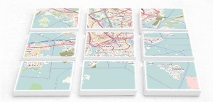
Customers of our raster tile server plans "small", "medium", and "large" can choose between from the following map styles:
You are not limited to the above styles if you use a dedicated tile server which we set up and run for you (XXL plan). On request, we can add a different map style or develop a new one for you. Please have a look at our map style gallery for inspiration.
Select map style:
| Plan | maximum tiles per month | Price without VAT |
|---|---|---|
| Small | 100.000 | EUR 40 per month |
| Medium | 1.000.000 | EUR 80 per month |
| Large | 10.000.000 | EUR 160 per month |
| XXL | unlimited | starting at EUR 550 per month |
The fees are charged for one year in advance on signup.
This service is provided for interactive maps which need to show the requested tiles as quickly as possible. If you want to download a large number of tiles in one go, our tile packages and bulk tile server access might be a better solution for you.
XXL: If you believe that our monthly tile quotas aren't sufficient for your use case, then you can order a dedicated server. That way you have full control over how many tiles you download at which priorities. Of course we can also install your individual map style on such a server. Please get in touch if you are interested.
Tiles as billing unit: Our billing is based on the number of requested tiles, not the number of "map views". Clients are provided with a login to our statistics portal where they can check their actual usage.
Caching by the customer: Our tile server offers do not have any restrictions regarding caching by our customers. You may use your own content delivery network as a proxy.
The "small", "medium", and "large" plans include the usage of our geocoding service based on Nominatim within reason in order to allow our clients to add a search box to their map applications. The included service is not intended for systematic geocoding, bulk geocoding and auto completion. We reserve the right to renegotiate the contract if the usage is too high. Larger contingents can be ordered if necessary.
All our tile server rates include the usage of our Static Map service. It returns a static image in PNG format for a given coordinate and zoom level. The image is created by stitching together the individual map tiles on server side. It is often necessary in content management systems which permit the inclusion of static images only. Overlays, such as markers, lines or polygons, can be added using URL parameters. The generated map images are cached on the server. Our Static Map service is based on the software GfStaticmap.
Billing is based on the number of tiles requested by the Static Map service from our tile servers.